
Alfter
Rheinweg, 53347 Alfter, Deutschland
Landscape Gate Green C | Park & Recreation in Alfter
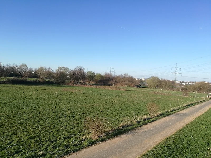
The Landscape Gate Green C in Alfter is not a classic event center, but a special park and landscape area on the Rheinweg that marks the transition into the regional open space project Green C. Those looking for a quiet place where landscape, movement, and orientation come together will find here a very typical access point for the green-connected region around Bonn and the left bank of the Rhine. The available park data lists the location as a park, mentions an area of 3.9 acres, suitability for walks, a picnic area, and bicycle parking. At the same time, Green C itself is a cross-municipal project aimed at securing, connecting, and making open spaces accessible to the public. Thus, the Landscape Gate Green C is less of a single excursion destination and more of a visible starting point into a larger cultural landscape that mediates between agriculture, recreation, and nature conservation. ([mypacer.com](https://www.mypacer.com/parks/205141/grunes-c-landschaftstor-alfter))
What is the Landscape Gate Green C in Alfter?
The term Landscape Gate is deliberately chosen in the context of Green C: The gates mark, according to the project description, particularly heavily used transitions from the settlement into the landscape and inform passersby about the space they are entering or leaving. The Landscape Gate in Alfter fulfills exactly this function as an entry situation into a landscape that is not only meant to look beautiful but also conveys path relationships, orientation, and regional identity. The project page describes Green C as an open space network that connects areas in the north of Bonn and creates bridges across the Rhine. The landscapes are under pressure from settlement expansion, edge development, economic growth, agricultural use, recreation, and nature and landscape conservation. For this reason, the Landscape Gate in Alfter is more than just a simple park name: it represents a transition where the green infrastructure of the region becomes visible, and the visitor enters not into an isolated single park but into a coherent system of open spaces. ([regionale2010.de](https://www.regionale2010.de/projekte/projekt/wachstum-und-wandel-gestalten/gruenes-c))
The location and classification as a park also confirm this role. Mapcarta lists the Landscape Gate Green C as a park in Alfter in the Rhein-Sieg-Kreis and mentions nearby areas such as Green C - Zehntfreiacker and Green C - Compensation Area. In the vicinity, Schloss Alfter, the Alanus University of Arts and Society, and St. James' Parish Church are also mentioned, which shows the embedding in a diverse local and landscape area. For the search intent around landscape gate, green c, and park alfter, this is important: Those looking for this place do not expect an event hall, tickets, or a seating plan, but rather a well-connected, landscape-shaped place for movement, short stays, and entry into the regional path network. This expectation is supported by the available map data and project information. ([mapcarta.com](https://mapcarta.com/W151483179))
What role does Green C play as an open space network?
Green C is a joint open space project of the cities and municipalities of Alfter, Bonn, Bornheim, Niederkassel, Sankt Augustin, and Troisdorf. The project description states the goal of securing, connecting, and developing the diverse open spaces of the region in the long term. Spanning an area of about 37 square kilometers, the area stretches from north to south over approximately 9 kilometers and from west to east over 17.5 kilometers. It includes fields for crops, fruit, and gardening, old cultural landscapes, nature reserves, rivers and banks, gravel pits, economic paths, country roads, highways, and utility corridors. This mix makes it understandable why the Landscape Gate Green C in Alfter is so important: It stands at a place where not only nature is experienced, but also the tension between use, protection, and development becomes visible. The project is unique in Germany and has been funded according to Troisdorf City by the Federal Ministry, the state of North Rhine-Westphalia, and the European Union. ([troisdorf.city](https://www.troisdorf.city/Unternehmen-Geschaefte-mehr/Projekt-das-Gruene-C))
A central element of Green C is the so-called Link. The city of Sankt Augustin describes it as the connecting element of Green C, thus as a path in different forms that invites walking, cycling, or inline skating. Starting from the bridge over the Rhine at the Mondorf ferry, this network of paths branches out through the landscape areas of the region. Stations and information boards provide interesting facts about the respective areas, while landscape gates mark particularly prominent transitions from the settlement area into the landscape. It is precisely in this system that the Landscape Gate in Alfter is integrated: It is a place of readability, not just a place of movement. Those arriving here enter a landscape space that has been deliberately designed as a park of cultural landscapes, whose main idea is to understand the region as a coherent open space. ([sankt-augustin.de](https://www.sankt-augustin.de/umwelt-klima/stadtgruen/))
Location on Rheinweg: Access, Orientation, and Surroundings
The Landscape Gate Green C is located on Rheinweg in 53347 Alfter. In the OpenStreetMap-based park data, the location is listed with the coordinates 50.73497 and 7.03122. Thus, it is situated in a location that is well-suited for walks and short excursions, without having the character of an urban hub. The classification as a park and recreational area shows that the place functions more as a quiet landscape access than as a densely packed attraction. Particularly helpful for orientation is that the place does not appear isolated in directories but is embedded in a series of neighboring green spaces and landscape sub-areas. Nearby areas include Green C - Zehntfreiacker and Green C - Compensation Area, which are neighboring areas of the same spatial system. Therefore, those searching for the location should not only remember the address Rheinweg but also understand it as part of a broader Green C structure. ([mypacer.com](https://www.mypacer.com/parks/205141/grunes-c-landschaftstor-alfter))
The surroundings additionally make the area attractive. Mapcarta mentions Alanus University of Arts and Society about 1.25 kilometers north, Schloss Alfter about 1.5 kilometers west, and St. James' Parish Church about 1.5 kilometers southwest of the Landscape Gate. Additionally, Tannenbusch, Duisdorf, and Roisdorf are mentioned as nearby places. This neighborhood shows that the Landscape Gate is not located in an isolated edge area but mediates between settlement areas, cultural sites, and open spaces. Those moving around here experience not only free landscape but also transitions between town centers, university environments, historical architecture, and regional green corridors. For visitors, this is particularly convenient because a stay at the Landscape Gate can be combined with further paths, small detours, or conscious local orientation. This is a significant appeal of Green C: The landscape is experienced not as a remote area but as a connected part of the region. ([mapcarta.com](https://mapcarta.com/W151483179))
Walking, Cycling, and Recreation in Green C
The available data and project descriptions clearly support the use as a place of recreation. Mypacer explicitly lists the Landscape Gate Green C as suitable for walks and mentions a picnic area and bicycle parking. At the same time, the city of Sankt Augustin describes the Link of Green C as a path system that invites walking, cycling, and inline skating. Together, this creates a coherent picture: The Landscape Gate Alfter is an access point for movement in open space, not a place for loud events. This quieter quality makes it interesting for many visitors, as it offers a conscious contrast to the densely populated Bonn-Cologne region, where free spaces are particularly valuable. Those moving around here do not use the landscape as a backdrop but as part of a larger experience of walking, cycling, orienting, and short breaks in nature. ([mypacer.com](https://www.mypacer.com/parks/205141/grunes-c-landschaftstor-alfter))
The larger context also supports this use. The project page of Green C describes the goal of securing open spaces while considering their specific characteristics and making them accessible to the public. This is why the mix of agriculture, nature, proximity to water, and paths is so important. Green C aims not only to protect areas but also to enhance the understandability of the landscape. A tour at the Landscape Gate Green C means: One moves in an area where the transitions between fields, green corridors, and settlement edges remain consciously readable. The place is therefore well-suited for shorter stays, walks with a view of the regional structure, and as a starting point for longer distances within the Green C network. Those arriving by bicycle benefit from the mentioned bicycle parking facilities and from the integration into the overarching path system. Those coming on foot find a quiet landscape access with a clear function. ([regionale2010.de](https://www.regionale2010.de/projekte/projekt/wachstum-und-wandel-gestalten/gruenes-c))
Landscape Space, Cultural Landscape, and Neighborhood
Green C is strongly connected to the concept of cultural landscape. Troisdorf City describes the project as a park of cultural landscapes between the cities that aims to secure the diverse open spaces of the region in the long term. It is not only about pure natural areas but about a mosaic of fields for crops, fruit, and gardening, old cultural landscapes, riverbanks, and traffic axes. This mix defines the quality of the space: The landscape is not wild in the strict sense but historically and functionally shaped. For the Landscape Gate in Alfter, this means that it not only marks the threshold to a green space but also to a region whose identity has been shaped by agriculture, settlement edges, and open pathways. Those visiting the place therefore experience a typical example of modern open space planning that does not pit use against protection but thinks spatially together. ([troisdorf.city](https://www.troisdorf.city/Unternehmen-Geschaefte-mehr/Projekt-das-Gruene-C))
In the immediate surroundings, additional qualities come into play. The proximity to Schloss Alfter and the Alanus University of Arts and Society gives the landscape space a cultural and educational component. At the same time, the neighboring sub-areas of Green C show that the place does not stand alone but is part of a gradually developed system. This makes orientation on-site particularly interesting for visitors: One moves between compensation areas, farmland, settlement edges, and other green structures without the landscape losing coherence. The project logic is therefore easily recognizable. Landscape gates mark the transitions, the Link connects the spaces, and the information carriers make the region readable. The Landscape Gate Green C in Alfter is therefore a good example of how open space planning can work today: not just as the design of an area but as the enhancement of an entire landscape relationship. ([mapcarta.com](https://mapcarta.com/W151483179))
Useful Information on Facilities, Size, and Stay
For visitors, the practical information is particularly relevant, and here the available material provides some clear pointers. The location is listed as a park with an area of 3.9 acres. A picnic area and bicycle parking are also mentioned. Several sources classify the location as a recreational or leisure area suitable for walking. This is important for a visitor description because it sets the expectations clearly: The Landscape Gate Green C is a quiet, open place for stay and movement, but not an event location with ticket sales, programmed seating, or fixed designated capacity. A reliable seating or event infrastructure is not specified in the sources found. This is why the term Landscape Gate fits so well: It is about access to the space, not about a closed indoor offering. ([mypacer.com](https://www.mypacer.com/parks/205141/grunes-c-landschaftstor-alfter))
The regional classification also helps in planning a visit. Green C itself is a cross-border, inter-municipal project involving six participating cities and municipalities. It aims to secure, connect, and make the landscape spaces accessible to the public. This idea explains why the Landscape Gate in Alfter is so sensibly placed: It welcomes visitors at an edge from which they can enter the network of paths, viewpoints, and transitions. Those looking for a quiet walk will find a good starting point here. Those traveling by bike benefit from the integration into the regional path system. Those interested in landscape planning can recognize the principle of Green C particularly clearly at this location: an open, readable, connected cultural landscape through information and path guidance. For SEO and user intent, this is a strong combination of place, project, and use. ([regionale2010.de](https://www.regionale2010.de/projekte/projekt/wachstum-und-wandel-gestalten/gruenes-c))
Sources:
Show moreShow less
Landscape Gate Green C | Park & Recreation in Alfter
The Landscape Gate Green C in Alfter is not a classic event center, but a special park and landscape area on the Rheinweg that marks the transition into the regional open space project Green C. Those looking for a quiet place where landscape, movement, and orientation come together will find here a very typical access point for the green-connected region around Bonn and the left bank of the Rhine. The available park data lists the location as a park, mentions an area of 3.9 acres, suitability for walks, a picnic area, and bicycle parking. At the same time, Green C itself is a cross-municipal project aimed at securing, connecting, and making open spaces accessible to the public. Thus, the Landscape Gate Green C is less of a single excursion destination and more of a visible starting point into a larger cultural landscape that mediates between agriculture, recreation, and nature conservation. ([mypacer.com](https://www.mypacer.com/parks/205141/grunes-c-landschaftstor-alfter))
What is the Landscape Gate Green C in Alfter?
The term Landscape Gate is deliberately chosen in the context of Green C: The gates mark, according to the project description, particularly heavily used transitions from the settlement into the landscape and inform passersby about the space they are entering or leaving. The Landscape Gate in Alfter fulfills exactly this function as an entry situation into a landscape that is not only meant to look beautiful but also conveys path relationships, orientation, and regional identity. The project page describes Green C as an open space network that connects areas in the north of Bonn and creates bridges across the Rhine. The landscapes are under pressure from settlement expansion, edge development, economic growth, agricultural use, recreation, and nature and landscape conservation. For this reason, the Landscape Gate in Alfter is more than just a simple park name: it represents a transition where the green infrastructure of the region becomes visible, and the visitor enters not into an isolated single park but into a coherent system of open spaces. ([regionale2010.de](https://www.regionale2010.de/projekte/projekt/wachstum-und-wandel-gestalten/gruenes-c))
The location and classification as a park also confirm this role. Mapcarta lists the Landscape Gate Green C as a park in Alfter in the Rhein-Sieg-Kreis and mentions nearby areas such as Green C - Zehntfreiacker and Green C - Compensation Area. In the vicinity, Schloss Alfter, the Alanus University of Arts and Society, and St. James' Parish Church are also mentioned, which shows the embedding in a diverse local and landscape area. For the search intent around landscape gate, green c, and park alfter, this is important: Those looking for this place do not expect an event hall, tickets, or a seating plan, but rather a well-connected, landscape-shaped place for movement, short stays, and entry into the regional path network. This expectation is supported by the available map data and project information. ([mapcarta.com](https://mapcarta.com/W151483179))
What role does Green C play as an open space network?
Green C is a joint open space project of the cities and municipalities of Alfter, Bonn, Bornheim, Niederkassel, Sankt Augustin, and Troisdorf. The project description states the goal of securing, connecting, and developing the diverse open spaces of the region in the long term. Spanning an area of about 37 square kilometers, the area stretches from north to south over approximately 9 kilometers and from west to east over 17.5 kilometers. It includes fields for crops, fruit, and gardening, old cultural landscapes, nature reserves, rivers and banks, gravel pits, economic paths, country roads, highways, and utility corridors. This mix makes it understandable why the Landscape Gate Green C in Alfter is so important: It stands at a place where not only nature is experienced, but also the tension between use, protection, and development becomes visible. The project is unique in Germany and has been funded according to Troisdorf City by the Federal Ministry, the state of North Rhine-Westphalia, and the European Union. ([troisdorf.city](https://www.troisdorf.city/Unternehmen-Geschaefte-mehr/Projekt-das-Gruene-C))
A central element of Green C is the so-called Link. The city of Sankt Augustin describes it as the connecting element of Green C, thus as a path in different forms that invites walking, cycling, or inline skating. Starting from the bridge over the Rhine at the Mondorf ferry, this network of paths branches out through the landscape areas of the region. Stations and information boards provide interesting facts about the respective areas, while landscape gates mark particularly prominent transitions from the settlement area into the landscape. It is precisely in this system that the Landscape Gate in Alfter is integrated: It is a place of readability, not just a place of movement. Those arriving here enter a landscape space that has been deliberately designed as a park of cultural landscapes, whose main idea is to understand the region as a coherent open space. ([sankt-augustin.de](https://www.sankt-augustin.de/umwelt-klima/stadtgruen/))
Location on Rheinweg: Access, Orientation, and Surroundings
The Landscape Gate Green C is located on Rheinweg in 53347 Alfter. In the OpenStreetMap-based park data, the location is listed with the coordinates 50.73497 and 7.03122. Thus, it is situated in a location that is well-suited for walks and short excursions, without having the character of an urban hub. The classification as a park and recreational area shows that the place functions more as a quiet landscape access than as a densely packed attraction. Particularly helpful for orientation is that the place does not appear isolated in directories but is embedded in a series of neighboring green spaces and landscape sub-areas. Nearby areas include Green C - Zehntfreiacker and Green C - Compensation Area, which are neighboring areas of the same spatial system. Therefore, those searching for the location should not only remember the address Rheinweg but also understand it as part of a broader Green C structure. ([mypacer.com](https://www.mypacer.com/parks/205141/grunes-c-landschaftstor-alfter))
The surroundings additionally make the area attractive. Mapcarta mentions Alanus University of Arts and Society about 1.25 kilometers north, Schloss Alfter about 1.5 kilometers west, and St. James' Parish Church about 1.5 kilometers southwest of the Landscape Gate. Additionally, Tannenbusch, Duisdorf, and Roisdorf are mentioned as nearby places. This neighborhood shows that the Landscape Gate is not located in an isolated edge area but mediates between settlement areas, cultural sites, and open spaces. Those moving around here experience not only free landscape but also transitions between town centers, university environments, historical architecture, and regional green corridors. For visitors, this is particularly convenient because a stay at the Landscape Gate can be combined with further paths, small detours, or conscious local orientation. This is a significant appeal of Green C: The landscape is experienced not as a remote area but as a connected part of the region. ([mapcarta.com](https://mapcarta.com/W151483179))
Walking, Cycling, and Recreation in Green C
The available data and project descriptions clearly support the use as a place of recreation. Mypacer explicitly lists the Landscape Gate Green C as suitable for walks and mentions a picnic area and bicycle parking. At the same time, the city of Sankt Augustin describes the Link of Green C as a path system that invites walking, cycling, and inline skating. Together, this creates a coherent picture: The Landscape Gate Alfter is an access point for movement in open space, not a place for loud events. This quieter quality makes it interesting for many visitors, as it offers a conscious contrast to the densely populated Bonn-Cologne region, where free spaces are particularly valuable. Those moving around here do not use the landscape as a backdrop but as part of a larger experience of walking, cycling, orienting, and short breaks in nature. ([mypacer.com](https://www.mypacer.com/parks/205141/grunes-c-landschaftstor-alfter))
The larger context also supports this use. The project page of Green C describes the goal of securing open spaces while considering their specific characteristics and making them accessible to the public. This is why the mix of agriculture, nature, proximity to water, and paths is so important. Green C aims not only to protect areas but also to enhance the understandability of the landscape. A tour at the Landscape Gate Green C means: One moves in an area where the transitions between fields, green corridors, and settlement edges remain consciously readable. The place is therefore well-suited for shorter stays, walks with a view of the regional structure, and as a starting point for longer distances within the Green C network. Those arriving by bicycle benefit from the mentioned bicycle parking facilities and from the integration into the overarching path system. Those coming on foot find a quiet landscape access with a clear function. ([regionale2010.de](https://www.regionale2010.de/projekte/projekt/wachstum-und-wandel-gestalten/gruenes-c))
Landscape Space, Cultural Landscape, and Neighborhood
Green C is strongly connected to the concept of cultural landscape. Troisdorf City describes the project as a park of cultural landscapes between the cities that aims to secure the diverse open spaces of the region in the long term. It is not only about pure natural areas but about a mosaic of fields for crops, fruit, and gardening, old cultural landscapes, riverbanks, and traffic axes. This mix defines the quality of the space: The landscape is not wild in the strict sense but historically and functionally shaped. For the Landscape Gate in Alfter, this means that it not only marks the threshold to a green space but also to a region whose identity has been shaped by agriculture, settlement edges, and open pathways. Those visiting the place therefore experience a typical example of modern open space planning that does not pit use against protection but thinks spatially together. ([troisdorf.city](https://www.troisdorf.city/Unternehmen-Geschaefte-mehr/Projekt-das-Gruene-C))
In the immediate surroundings, additional qualities come into play. The proximity to Schloss Alfter and the Alanus University of Arts and Society gives the landscape space a cultural and educational component. At the same time, the neighboring sub-areas of Green C show that the place does not stand alone but is part of a gradually developed system. This makes orientation on-site particularly interesting for visitors: One moves between compensation areas, farmland, settlement edges, and other green structures without the landscape losing coherence. The project logic is therefore easily recognizable. Landscape gates mark the transitions, the Link connects the spaces, and the information carriers make the region readable. The Landscape Gate Green C in Alfter is therefore a good example of how open space planning can work today: not just as the design of an area but as the enhancement of an entire landscape relationship. ([mapcarta.com](https://mapcarta.com/W151483179))
Useful Information on Facilities, Size, and Stay
For visitors, the practical information is particularly relevant, and here the available material provides some clear pointers. The location is listed as a park with an area of 3.9 acres. A picnic area and bicycle parking are also mentioned. Several sources classify the location as a recreational or leisure area suitable for walking. This is important for a visitor description because it sets the expectations clearly: The Landscape Gate Green C is a quiet, open place for stay and movement, but not an event location with ticket sales, programmed seating, or fixed designated capacity. A reliable seating or event infrastructure is not specified in the sources found. This is why the term Landscape Gate fits so well: It is about access to the space, not about a closed indoor offering. ([mypacer.com](https://www.mypacer.com/parks/205141/grunes-c-landschaftstor-alfter))
The regional classification also helps in planning a visit. Green C itself is a cross-border, inter-municipal project involving six participating cities and municipalities. It aims to secure, connect, and make the landscape spaces accessible to the public. This idea explains why the Landscape Gate in Alfter is so sensibly placed: It welcomes visitors at an edge from which they can enter the network of paths, viewpoints, and transitions. Those looking for a quiet walk will find a good starting point here. Those traveling by bike benefit from the integration into the regional path system. Those interested in landscape planning can recognize the principle of Green C particularly clearly at this location: an open, readable, connected cultural landscape through information and path guidance. For SEO and user intent, this is a strong combination of place, project, and use. ([regionale2010.de](https://www.regionale2010.de/projekte/projekt/wachstum-und-wandel-gestalten/gruenes-c))
Sources:
Frequently Asked Questions
Reviews
No reviews found