
Bonn
Melbweg, 53127 Bonn, Deutschland
Historic Bridge Melbtal from 1842 | Melb Bridge & Melbtal
The sought-after Melb Bridge, known as the Historic Bridge Melbtal from 1842, is one of the most impressive small monuments in the Bonn area. It is located in the Melbtal between Ippendorf and Venusberg, spans the Engelsbach, and is situated in a landscape that has been protected as a nature reserve since 2013. Unlike large event locations, this place thrives not on noise, but on tranquility, history, and a very clear connection between architecture and nature. This mix ensures that people search for the Melb Bridge, the Melbtal loop, Gut Melb, the Melbgarten, and the access to Melbtal. Those who come here find not a staged visitor operation, but a path that feels like a piece of living Bonn city and landscape history. The bridge is thus not only a photographic motif but also a focal point for all those who wish to connect historical bridges, monuments, walking paths, and nature-oriented excursion destinations in Bonn. ([bonn.de](https://www.bonn.de/themen-entdecken/umwelt-natur/naturschutzgebiet-melbtal.php?loc=en))
Historic Bridge Melbtal from 1842: History, Location, and Monument Value
The popular designation Historic Bridge Melbtal from 1842 leads directly to the Melb Bridge, which is described as a three-arched stone bridge from the 19th century. In Bonn's landscape and monument tradition, it is clearly associated with the Melbtal; at the same time, the dating shows that historical buildings often have multiple recorded dates. While the search term refers to 1842, professional sources date the construction of the bridge around 1845, presumably in connection with the neighboring Gut Melb. This small range is typical for historical infrastructure: A building is planned, constructed, later maintained, and ultimately perceived in a new context. For SEO, this is exciting because searchers are not only looking for the place itself but also for its origin, its classification as a monument, and its connection to the landscape of the Melbtal. ([de.wikipedia.org](https://de.wikipedia.org/wiki/Melbbr%C3%BCcke))
Historically, the bridge is part of an ensemble that encompasses much more than just a crossing over the stream. Sources mention Gut Melb, the bridge over the Engelsbach, and the nearby caretaker's house as a cohesive monument-protected entity. The estate was built in the 19th century, remodeled several times, and acquired its currently visible neoclassical features. In 1938, the then-owner Otto Boeddinghaus sold the estate to the city of Bonn; today it is owned by the NRW construction and property management and is leased to the University of Bonn, but has been vacant since 2016. This keeps the bridge from being isolated, making it readable as part of a historical cultural landscape. So, anyone searching for the history, background, or historical development of bridges will find a real example of how a small engineering structure merges with agriculture, landscape design, and urban development over generations. ([kuladig.de](https://www.kuladig.de/Objektansicht/KLD-345316))
An important cultural reference point is also the artistic tradition. In 1852, Johann Wilhelm Schirmer painted the Melbtal with the bridge, making the structure early on a picturesque motif. In 1902, a restoration took place, and in 1971/72, the bridge was extensively renovated; among other things, unsafe end walls and parapets were removed, and a reinforced concrete structure was created to accommodate traffic loads. This illustrates very well how historical bridges continue to live on: Not as museum objects behind barriers, but as adapted, preserved structures that connect history, use, and safety. This mix of age, renewal, and continuity makes the Melb Bridge a strong search term for visitors interested in the historical development of bridges, monument protection, and regional architectural history. ([de.wikipedia.org](https://de.wikipedia.org/wiki/Melbbr%C3%BCcke))
Melb Bridge: Construction, Dimensions, and Architectural Details
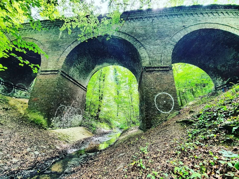
The architectural quality of the Melb Bridge lies in its clear, craftily readable construction. According to professional descriptions, it is entirely built of field-fired bricks; only the foundation bases are made of rubble stones. Three approximately equally sized circular segment arches support the structure, and each arch has a span of 6.15 meters. With a length of 41.20 meters and a width of 5.00 meters, the bridge appears both compact and robust. These dimensions are not spectacular in terms of a large structure, but that is exactly what makes its charm: It is a precise, landscape-embedded building that combines the function of a valley crossing with a simple, historical design language. Therefore, those searching for Melb Bridge, Melbtal Bridge, or historical bridge Bonn do not end up at a modern traffic machine, but at a well-proportioned monument that fits very naturally into the valley space. ([de.wikipedia.org](https://de.wikipedia.org/wiki/Melbbr%C3%BCcke))
Particularly interesting is the development from a purely utilitarian structure to a protected cultural monument. The bridge was built, used, repaired, and renovated without losing its historical character. This is a nice example of the historical development of bridges: Many older valley and stream bridges had to undergo technical adjustments over time to meet today's requirements. In the case of the Melb Bridge, such interventions were visible but not destructively implemented. The professional description makes it clear that the bridge is not just a romantic backdrop, but a serious technical object of the 19th century, whose current form consists of several layers. This creates trust among visitors who want to bring not only beautiful photos but also a real understanding of construction, statics, and monument preservation. ([de.wikipedia.org](https://de.wikipedia.org/wiki/Melbbr%C3%BCcke))
That the bridge is a protected monument is a reason for many users to search. In the Bonn region, the monument stock is large, and the Melb Bridge belongs with Gut Melb and the caretaker's house to a registered monument. Such entries are not only legally important but also for the perception in the urban landscape: They state that a place cannot be arbitrarily changed and that its historical character should be consciously preserved. For the presentation on a location page, this means presenting the bridge as a quiet but valuable cultural monument. Visitors do not seek a show here, but authenticity. That is why terms like monument protection, historical bridge, Melb Bridge, and Bonn are so relevant, as they cover the factual side of this place while simultaneously conveying the emotional fascination of a quiet structure in the green. ([kuladig.de](https://www.kuladig.de/Objektansicht/KLD-345316))
The Melbtal as a Nature Reserve and Fresh Air Corridor
Anyone visiting the bridge also experiences the Melbtal itself. The city of Bonn describes the area as a nature reserve covering around 20 hectares, located between Ippendorf and Poppelsdorf. The steep, partly deeply incised valley form of the Engelsbach is protected, featuring a near-natural forest stream, moor and seepage springs, as well as the accompanying slope forests. For urban ecology, the valley is particularly important because it forms a habitat for numerous rare and endangered animal and plant species, especially for birds, bats, and amphibians. Thus, the Melbtal is not only the backdrop of the bridge but also a habitat worth protecting. Search queries for nature reserve Melbtal, Melbtal Bonn, or Engelsbach Bonn specifically target this combination of proximity to the city center and ecological quality. ([bonn.de](https://www.bonn.de/themen-entdecken/umwelt-natur/naturschutzgebiet-melbtal.php?loc=en))
The name of the valley also tells a story. The Nature Park Rheinland explains that the name Melb can be traced back to Celtic roots and means “yellow-brown water.” The coloration of the stream becomes visible after prolonged rainfall and is explained by the loess-clay layers of the streambed. This is a small but strong detail because it makes the landscape immediately readable: The water, the soil, and the color of the stream are interconnected. For visitors, this is exactly the kind of information that deepens a walk. Those who understand the bridge not just as an object but as part of a geological and hydrological system perceive the place more consciously. Such facts make the difference between a mere location reference and a high-quality, intent-driven description. ([naturpark-rheinland.de](https://www.naturpark-rheinland.de/melbtal-runde))
Additionally, the valley has a special climatic function. In Bonn's tradition, the Melbtal wind is described as a nocturnal cold air outflow that measurably contributes to temperature reduction in summer. Up to 3 degrees Celsius are mentioned in the foot of the slope area, up to 2 degrees at Poppelsdorf Castle, and still 1 degree in parts of Poppelsdorfer Allee. For an urban location, this is remarkable because it shows that the Melbtal is not only beautiful but also climatically effective. This fresh air corridor fits very well with Bonn's reputation as a green city and explains why the valley has long been appreciated for its landscape and urban climate. For a location page, this is a valuable argument: The bridge is not located in an isolated park but in an active nature and climate area that significantly shapes Bonn. ([de.wikipedia.org](https://de.wikipedia.org/wiki/Melbtal))
Hiking on the Melbtal Loop: Paths, Viewpoints, and Rules
The best approach to the historic bridge is often not by car, but by hiking. The Nature Park Rheinland describes the Melbtal loop as a 10.4-kilometer circular path around the Venusberg through the wooded nature reserve Melbtal. On this route, the Melb Bridge is one of the highlights, along with Gut Melb, the Melbgarten, the Kaiser Wilhelm Monument, and the Head Beech Bridge. Several viewpoints on the Venusberg offer views of Bonn and the Siebengebirge, and at the Head Beech Bridge, one can look into the so-called ghost beeches, i.e., old trees with quirky shapes and valuable tree cavities. For users searching for Melbtal loop, hiking Bonn, or Melbtal Bonn, this is exactly the content they expect: a combinable excursion destination with nature, history, and views. ([naturpark-rheinland.de](https://www.naturpark-rheinland.de/melbtal-runde))
Particularly practical is that the Melbtal loop is a circular hiking trail. The starting and ending point as well as the direction of travel are freely selectable. The Nature Park lists P1 Waldau, H1 Waldau, H2 Casselsruhe, and H3 Clemens-August-Platz as entry points. This makes the route flexible for different starting points in Bonn. So, anyone wanting to incorporate the bridge into a short or longer tour can adjust the circular path accordingly. This is important in terms of search intent because many visitors do not just want to see a destination but want to know how to meaningfully integrate it into a walk or half-day hike. The information about the entry points is therefore not just additional knowledge but a real part of the user experience. ([naturpark-rheinland.de](https://www.naturpark-rheinland.de/melbtal-runde))
Equally important are the rules in the protected area. The Nature Park Rheinland explicitly points out to use only paved paths, to leave plants and animals where they naturally are, to take waste back with them, to leash dogs, and not to light fires. Swimming is only allowed at designated spots, and mutual consideration is also emphasized. For visitors, this is a clear orientation: The Melbtal is a sensitive natural area, not a freely usable city park. Those who are out here respect not only the landscape but also secure the character of the valley for the future. For an SEO page, this point is valuable because it fulfills the search intent for responsible, realistic visitor information while correctly conveying the character of the place. ([naturpark-rheinland.de](https://www.naturpark-rheinland.de/melbtal-runde))
Access to the Bridge: Waldau, Casselsruhe, Clemens-August-Platz, and the Best Access
The best way to reach the historic bridge is through the paths of the Melbtal itself. The official route description makes it clear that Waldau is a central entry point and that the Melbtal loop begins at several Bonn stops. This is particularly helpful for access because it is not just about a single parking space, but about a whole network of access points. Those coming from the city center can thus easily reach the bridge using public transport and a subsequent walk. This fits the character of the place: The bridge is not a destination for fast through traffic but a place for slow approach. This is also an important SEO aspect because searchers looking for access, Melbtal, hiking, and parking questions usually want a solution that is as simple as possible but also honest. ([naturpark-rheinland.de](https://www.naturpark-rheinland.de/melbtal-runde))
For visitors wishing to include the Melbgarten, the University of Bonn provides additional practical orientation. The Melbgarten is normally not publicly accessible, and the university points out that there are hardly any parking spaces; bus or bicycle is recommended. Once a year, usually in spring, the outdoor area is publicly accessible, and guided tours can also be booked. This is interesting for the area around the bridge because many guests plan their excursion in this valley area and want to combine several destinations. Therefore, when searching for access Melbtal or Melbgarten Bonn, one should take the limited parking situation seriously and rather calculate with public transport or bike. This makes the visit more relaxed and also fits the sensitive natural backdrop of the valley. ([botgart.uni-bonn.de](https://www.botgart.uni-bonn.de/de/die-gaerten/melbgarten))
The lower end of the valley is also helpful for orientation. In the tradition of the Melbtal, the Melbbad is mentioned as the lower end of the valley, while the bridge is only separated from it by a field. So, anyone visiting the bridge has a clear geographical reference point: Melbbad below, Waldau above, with a valley shaped by footpaths and historical and landscape intermediate stations in between. This clear valley axis makes it easy to understand the place and incorporate it into a route. That is why search terms like access Melbtal, Melbbad, or Venusberg Bonn work very well together: They describe the same space from different perspectives. ([de.wikipedia.org](https://de.wikipedia.org/wiki/Melbtal))
Gut Melb, Melbgarten, and the Main Highlights Around the Bridge
Surrounding the Melb Bridge is a small but dense network of attractions. The most important adjacent motif is Gut Melb, which was established in the 19th century and has been remodeled several times over time. The estate includes several agricultural buildings, stables, a manor house, a bridge over the Engelsbach, and a nearby caretaker's house; its size is stated to be 38.44 hectares. The development shows that the Melbtal was not only a natural area but also a historically utilized economic space. This is interesting for visitors because agriculture, noble estates, university use, and monument preservation overlap here. Those searching for Gut Melb, Melbtal Bonn, or Melb Bridge are often looking for this connection between cultural history and landscape. ([kuladig.de](https://www.kuladig.de/Objektansicht/KLD-345316))
Another highlight is the Melbgarten of the Botanical Gardens of the University of Bonn. The official site describes it as an outdoor area of 1.8 hectares in the Melbtal. Once a year, usually in spring, the collections of Asian trees, hardy camellias, and Georgian plants are publicly accessible; additionally, guided tours can be booked. The background is also remarkable: Towards the end of World War II, the city of Bonn granted the university an idyllic area in the Melbtal for experimental facilities. Particularly plants from Georgia and China found a new home here, and in the China Forest, over 50-year-old prehistoric giant sequoias grow. This adds a botanical and scientific dimension to the valley area, which is very typical for Bonn. ([botgart.uni-bonn.de](https://www.botgart.uni-bonn.de/de/die-gaerten/melbgarten))
The route also includes the Kaiser Wilhelm Monument and the Head Beech Bridge, both mentioned as fixed points of the Melbtal loop. The ghost beeches at the Head Beech Bridge are valuable habitats for tawny owls, woodpeckers, and bats with their tree cavities. Together with the viewpoints on the Venusberg, this creates a very versatile excursion: historic bridge, monument, botanical garden, old trees, and wide views of Bonn and the Siebengebirge. This mix makes the place so attractive for seekers. It is small enough to remain quiet but rich enough to cover an entire thematic world. Therefore, keywords like historical bridge, Melb Bridge, Melbtal Bridge, nature reserve Melbtal, Melbtal loop, Gut Melb, and Melbgarten work particularly well together here. ([naturpark-rheinland.de](https://www.naturpark-rheinland.de/melbtal-runde))
Sources:
Show moreShow less
Historic Bridge Melbtal from 1842 | Melb Bridge & Melbtal
The sought-after Melb Bridge, known as the Historic Bridge Melbtal from 1842, is one of the most impressive small monuments in the Bonn area. It is located in the Melbtal between Ippendorf and Venusberg, spans the Engelsbach, and is situated in a landscape that has been protected as a nature reserve since 2013. Unlike large event locations, this place thrives not on noise, but on tranquility, history, and a very clear connection between architecture and nature. This mix ensures that people search for the Melb Bridge, the Melbtal loop, Gut Melb, the Melbgarten, and the access to Melbtal. Those who come here find not a staged visitor operation, but a path that feels like a piece of living Bonn city and landscape history. The bridge is thus not only a photographic motif but also a focal point for all those who wish to connect historical bridges, monuments, walking paths, and nature-oriented excursion destinations in Bonn. ([bonn.de](https://www.bonn.de/themen-entdecken/umwelt-natur/naturschutzgebiet-melbtal.php?loc=en))
Historic Bridge Melbtal from 1842: History, Location, and Monument Value
The popular designation Historic Bridge Melbtal from 1842 leads directly to the Melb Bridge, which is described as a three-arched stone bridge from the 19th century. In Bonn's landscape and monument tradition, it is clearly associated with the Melbtal; at the same time, the dating shows that historical buildings often have multiple recorded dates. While the search term refers to 1842, professional sources date the construction of the bridge around 1845, presumably in connection with the neighboring Gut Melb. This small range is typical for historical infrastructure: A building is planned, constructed, later maintained, and ultimately perceived in a new context. For SEO, this is exciting because searchers are not only looking for the place itself but also for its origin, its classification as a monument, and its connection to the landscape of the Melbtal. ([de.wikipedia.org](https://de.wikipedia.org/wiki/Melbbr%C3%BCcke))
Historically, the bridge is part of an ensemble that encompasses much more than just a crossing over the stream. Sources mention Gut Melb, the bridge over the Engelsbach, and the nearby caretaker's house as a cohesive monument-protected entity. The estate was built in the 19th century, remodeled several times, and acquired its currently visible neoclassical features. In 1938, the then-owner Otto Boeddinghaus sold the estate to the city of Bonn; today it is owned by the NRW construction and property management and is leased to the University of Bonn, but has been vacant since 2016. This keeps the bridge from being isolated, making it readable as part of a historical cultural landscape. So, anyone searching for the history, background, or historical development of bridges will find a real example of how a small engineering structure merges with agriculture, landscape design, and urban development over generations. ([kuladig.de](https://www.kuladig.de/Objektansicht/KLD-345316))
An important cultural reference point is also the artistic tradition. In 1852, Johann Wilhelm Schirmer painted the Melbtal with the bridge, making the structure early on a picturesque motif. In 1902, a restoration took place, and in 1971/72, the bridge was extensively renovated; among other things, unsafe end walls and parapets were removed, and a reinforced concrete structure was created to accommodate traffic loads. This illustrates very well how historical bridges continue to live on: Not as museum objects behind barriers, but as adapted, preserved structures that connect history, use, and safety. This mix of age, renewal, and continuity makes the Melb Bridge a strong search term for visitors interested in the historical development of bridges, monument protection, and regional architectural history. ([de.wikipedia.org](https://de.wikipedia.org/wiki/Melbbr%C3%BCcke))
Melb Bridge: Construction, Dimensions, and Architectural Details
The architectural quality of the Melb Bridge lies in its clear, craftily readable construction. According to professional descriptions, it is entirely built of field-fired bricks; only the foundation bases are made of rubble stones. Three approximately equally sized circular segment arches support the structure, and each arch has a span of 6.15 meters. With a length of 41.20 meters and a width of 5.00 meters, the bridge appears both compact and robust. These dimensions are not spectacular in terms of a large structure, but that is exactly what makes its charm: It is a precise, landscape-embedded building that combines the function of a valley crossing with a simple, historical design language. Therefore, those searching for Melb Bridge, Melbtal Bridge, or historical bridge Bonn do not end up at a modern traffic machine, but at a well-proportioned monument that fits very naturally into the valley space. ([de.wikipedia.org](https://de.wikipedia.org/wiki/Melbbr%C3%BCcke))
Particularly interesting is the development from a purely utilitarian structure to a protected cultural monument. The bridge was built, used, repaired, and renovated without losing its historical character. This is a nice example of the historical development of bridges: Many older valley and stream bridges had to undergo technical adjustments over time to meet today's requirements. In the case of the Melb Bridge, such interventions were visible but not destructively implemented. The professional description makes it clear that the bridge is not just a romantic backdrop, but a serious technical object of the 19th century, whose current form consists of several layers. This creates trust among visitors who want to bring not only beautiful photos but also a real understanding of construction, statics, and monument preservation. ([de.wikipedia.org](https://de.wikipedia.org/wiki/Melbbr%C3%BCcke))
That the bridge is a protected monument is a reason for many users to search. In the Bonn region, the monument stock is large, and the Melb Bridge belongs with Gut Melb and the caretaker's house to a registered monument. Such entries are not only legally important but also for the perception in the urban landscape: They state that a place cannot be arbitrarily changed and that its historical character should be consciously preserved. For the presentation on a location page, this means presenting the bridge as a quiet but valuable cultural monument. Visitors do not seek a show here, but authenticity. That is why terms like monument protection, historical bridge, Melb Bridge, and Bonn are so relevant, as they cover the factual side of this place while simultaneously conveying the emotional fascination of a quiet structure in the green. ([kuladig.de](https://www.kuladig.de/Objektansicht/KLD-345316))
The Melbtal as a Nature Reserve and Fresh Air Corridor
Anyone visiting the bridge also experiences the Melbtal itself. The city of Bonn describes the area as a nature reserve covering around 20 hectares, located between Ippendorf and Poppelsdorf. The steep, partly deeply incised valley form of the Engelsbach is protected, featuring a near-natural forest stream, moor and seepage springs, as well as the accompanying slope forests. For urban ecology, the valley is particularly important because it forms a habitat for numerous rare and endangered animal and plant species, especially for birds, bats, and amphibians. Thus, the Melbtal is not only the backdrop of the bridge but also a habitat worth protecting. Search queries for nature reserve Melbtal, Melbtal Bonn, or Engelsbach Bonn specifically target this combination of proximity to the city center and ecological quality. ([bonn.de](https://www.bonn.de/themen-entdecken/umwelt-natur/naturschutzgebiet-melbtal.php?loc=en))
The name of the valley also tells a story. The Nature Park Rheinland explains that the name Melb can be traced back to Celtic roots and means “yellow-brown water.” The coloration of the stream becomes visible after prolonged rainfall and is explained by the loess-clay layers of the streambed. This is a small but strong detail because it makes the landscape immediately readable: The water, the soil, and the color of the stream are interconnected. For visitors, this is exactly the kind of information that deepens a walk. Those who understand the bridge not just as an object but as part of a geological and hydrological system perceive the place more consciously. Such facts make the difference between a mere location reference and a high-quality, intent-driven description. ([naturpark-rheinland.de](https://www.naturpark-rheinland.de/melbtal-runde))
Additionally, the valley has a special climatic function. In Bonn's tradition, the Melbtal wind is described as a nocturnal cold air outflow that measurably contributes to temperature reduction in summer. Up to 3 degrees Celsius are mentioned in the foot of the slope area, up to 2 degrees at Poppelsdorf Castle, and still 1 degree in parts of Poppelsdorfer Allee. For an urban location, this is remarkable because it shows that the Melbtal is not only beautiful but also climatically effective. This fresh air corridor fits very well with Bonn's reputation as a green city and explains why the valley has long been appreciated for its landscape and urban climate. For a location page, this is a valuable argument: The bridge is not located in an isolated park but in an active nature and climate area that significantly shapes Bonn. ([de.wikipedia.org](https://de.wikipedia.org/wiki/Melbtal))
Hiking on the Melbtal Loop: Paths, Viewpoints, and Rules
The best approach to the historic bridge is often not by car, but by hiking. The Nature Park Rheinland describes the Melbtal loop as a 10.4-kilometer circular path around the Venusberg through the wooded nature reserve Melbtal. On this route, the Melb Bridge is one of the highlights, along with Gut Melb, the Melbgarten, the Kaiser Wilhelm Monument, and the Head Beech Bridge. Several viewpoints on the Venusberg offer views of Bonn and the Siebengebirge, and at the Head Beech Bridge, one can look into the so-called ghost beeches, i.e., old trees with quirky shapes and valuable tree cavities. For users searching for Melbtal loop, hiking Bonn, or Melbtal Bonn, this is exactly the content they expect: a combinable excursion destination with nature, history, and views. ([naturpark-rheinland.de](https://www.naturpark-rheinland.de/melbtal-runde))
Particularly practical is that the Melbtal loop is a circular hiking trail. The starting and ending point as well as the direction of travel are freely selectable. The Nature Park lists P1 Waldau, H1 Waldau, H2 Casselsruhe, and H3 Clemens-August-Platz as entry points. This makes the route flexible for different starting points in Bonn. So, anyone wanting to incorporate the bridge into a short or longer tour can adjust the circular path accordingly. This is important in terms of search intent because many visitors do not just want to see a destination but want to know how to meaningfully integrate it into a walk or half-day hike. The information about the entry points is therefore not just additional knowledge but a real part of the user experience. ([naturpark-rheinland.de](https://www.naturpark-rheinland.de/melbtal-runde))
Equally important are the rules in the protected area. The Nature Park Rheinland explicitly points out to use only paved paths, to leave plants and animals where they naturally are, to take waste back with them, to leash dogs, and not to light fires. Swimming is only allowed at designated spots, and mutual consideration is also emphasized. For visitors, this is a clear orientation: The Melbtal is a sensitive natural area, not a freely usable city park. Those who are out here respect not only the landscape but also secure the character of the valley for the future. For an SEO page, this point is valuable because it fulfills the search intent for responsible, realistic visitor information while correctly conveying the character of the place. ([naturpark-rheinland.de](https://www.naturpark-rheinland.de/melbtal-runde))
Access to the Bridge: Waldau, Casselsruhe, Clemens-August-Platz, and the Best Access
The best way to reach the historic bridge is through the paths of the Melbtal itself. The official route description makes it clear that Waldau is a central entry point and that the Melbtal loop begins at several Bonn stops. This is particularly helpful for access because it is not just about a single parking space, but about a whole network of access points. Those coming from the city center can thus easily reach the bridge using public transport and a subsequent walk. This fits the character of the place: The bridge is not a destination for fast through traffic but a place for slow approach. This is also an important SEO aspect because searchers looking for access, Melbtal, hiking, and parking questions usually want a solution that is as simple as possible but also honest. ([naturpark-rheinland.de](https://www.naturpark-rheinland.de/melbtal-runde))
For visitors wishing to include the Melbgarten, the University of Bonn provides additional practical orientation. The Melbgarten is normally not publicly accessible, and the university points out that there are hardly any parking spaces; bus or bicycle is recommended. Once a year, usually in spring, the outdoor area is publicly accessible, and guided tours can also be booked. This is interesting for the area around the bridge because many guests plan their excursion in this valley area and want to combine several destinations. Therefore, when searching for access Melbtal or Melbgarten Bonn, one should take the limited parking situation seriously and rather calculate with public transport or bike. This makes the visit more relaxed and also fits the sensitive natural backdrop of the valley. ([botgart.uni-bonn.de](https://www.botgart.uni-bonn.de/de/die-gaerten/melbgarten))
The lower end of the valley is also helpful for orientation. In the tradition of the Melbtal, the Melbbad is mentioned as the lower end of the valley, while the bridge is only separated from it by a field. So, anyone visiting the bridge has a clear geographical reference point: Melbbad below, Waldau above, with a valley shaped by footpaths and historical and landscape intermediate stations in between. This clear valley axis makes it easy to understand the place and incorporate it into a route. That is why search terms like access Melbtal, Melbbad, or Venusberg Bonn work very well together: They describe the same space from different perspectives. ([de.wikipedia.org](https://de.wikipedia.org/wiki/Melbtal))
Gut Melb, Melbgarten, and the Main Highlights Around the Bridge
Surrounding the Melb Bridge is a small but dense network of attractions. The most important adjacent motif is Gut Melb, which was established in the 19th century and has been remodeled several times over time. The estate includes several agricultural buildings, stables, a manor house, a bridge over the Engelsbach, and a nearby caretaker's house; its size is stated to be 38.44 hectares. The development shows that the Melbtal was not only a natural area but also a historically utilized economic space. This is interesting for visitors because agriculture, noble estates, university use, and monument preservation overlap here. Those searching for Gut Melb, Melbtal Bonn, or Melb Bridge are often looking for this connection between cultural history and landscape. ([kuladig.de](https://www.kuladig.de/Objektansicht/KLD-345316))
Another highlight is the Melbgarten of the Botanical Gardens of the University of Bonn. The official site describes it as an outdoor area of 1.8 hectares in the Melbtal. Once a year, usually in spring, the collections of Asian trees, hardy camellias, and Georgian plants are publicly accessible; additionally, guided tours can be booked. The background is also remarkable: Towards the end of World War II, the city of Bonn granted the university an idyllic area in the Melbtal for experimental facilities. Particularly plants from Georgia and China found a new home here, and in the China Forest, over 50-year-old prehistoric giant sequoias grow. This adds a botanical and scientific dimension to the valley area, which is very typical for Bonn. ([botgart.uni-bonn.de](https://www.botgart.uni-bonn.de/de/die-gaerten/melbgarten))
The route also includes the Kaiser Wilhelm Monument and the Head Beech Bridge, both mentioned as fixed points of the Melbtal loop. The ghost beeches at the Head Beech Bridge are valuable habitats for tawny owls, woodpeckers, and bats with their tree cavities. Together with the viewpoints on the Venusberg, this creates a very versatile excursion: historic bridge, monument, botanical garden, old trees, and wide views of Bonn and the Siebengebirge. This mix makes the place so attractive for seekers. It is small enough to remain quiet but rich enough to cover an entire thematic world. Therefore, keywords like historical bridge, Melb Bridge, Melbtal Bridge, nature reserve Melbtal, Melbtal loop, Gut Melb, and Melbgarten work particularly well together here. ([naturpark-rheinland.de](https://www.naturpark-rheinland.de/melbtal-runde))
Sources:
Upcoming Events
No events found
Frequently Asked Questions
Reviews
Benek Mrozowski
26. November 2023
A great place for a walk in a big city, tranquility, peace, animals. I can really recommend it, and kids can experience a bit of freedom too.🫥😉
Dirk Roggendorf
9. November 2020
The Melbtal offers a beautiful piece of nature on the slope of Venus Mountain. Nice circular path, not always easy to walk.
YAZAN
27. November 2024
The bridge has such an old charm that perfectly fits into the surrounding nature. Walking over it gives you a really nice view, and the whole place invites you to linger. For anyone who loves to combine history and nature, it's definitely a highlight!
4 2
25. June 2025
So far, quite nice (as is the whole Melbtal around), but nothing spectacular either. If you just want to go for a nice walk, it's worth stopping by. But you shouldn't expect too much.
Birgit Scharrenbach
29. March 2025
You see exactly that. Quite interesting, as it wasn't even on my radar. A small nice walk, definitely recommendable.